[page 1, page 2, page 3, page 4, page 5, page 6, page 7, page 8,]
Researching Part 6: Examine the graphic of sea floor topography from gravity readings. Notice the great number of peninsulas, large islands (continental crust fragments), island arcs, and shallow seas in the western Pacific. Write an essay that discusses what will happen to these features as plate tectonics continues on into the future, and what are the implications to the future geology of the nearby continental land masses.
It seems that these island arcs are formed as the lithosphere moves over a hot spot in the asthenosphere, leaving a trail of volcanic islands. This is part of the ring of fire formed by the subduction zone where the Eurasian and Pacific plates are converging. Judging from how these phenomena are developing I would predict that as more and more islands are created and pushed against Asia, there will be more and more land mass filling in this part of the ocean. This will be somewhat offset by erosion. The continental land mass will also likely become more mountainous.
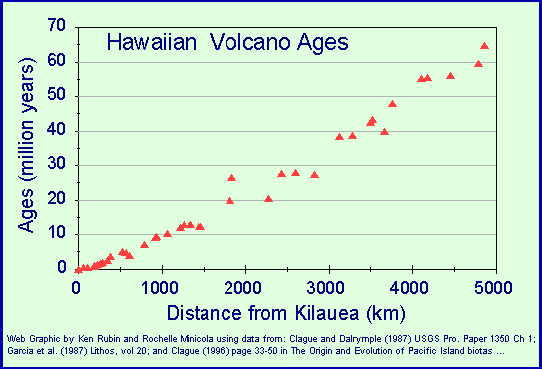
The Hawaiian Island-Hawaiian ridge-Emperor Seamount
structure is formed by the Pacific oceanic plate moving over the Hawaiian
hot spot, which is presently under the Big Island of Hawaii. As you
follow the trail of islands from the big island of Hawaiia towards the
northwest, the islands get older and older. This is illustrated in the
graph below:
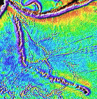 As shown in
the detail at right, there is a curious bend in direction of the archipelago
suggesting an abrupt change in the direction of the Pacific plate's movement
from north to northwest.
As shown in
the detail at right, there is a curious bend in direction of the archipelago
suggesting an abrupt change in the direction of the Pacific plate's movement
from north to northwest.
I found some nice pictures: http://www.ecuadortours.com/photo-gallery/andes/I-cotopaxi.jpg
http://www.ecuadortours.com/photo-gallery/andes/foto56.jpg
http://volcano.und.nodak.edu/vwdocs/volc_images/img_chufquen.html
The Andes Mountains are located generally in the subduction zone where
the the South American, Nazca, and Antarctic plates come together.
As described here,
there are 5 different types of volcanoes: the caldera type, which
is typified by Crater Lake, is formed by the collapse of a volcano; the
cinder
cone type is produced by lava piling up on a single vent; the shield
type is the result of countless outpourings of lava and leads to a broad,
gently sloping cone; the stratovolcano type where we have layer
upon layer of lava, ash and volcanic debris built up to form a steep, symmetrical
cone; and the lava dome type, which occurs when viscous lava piles up around
a vent. I must say I find these definitions to be rather undiscerning.
The differences are described in more
here.
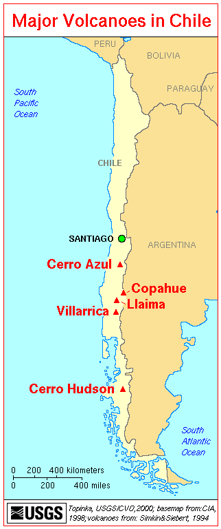
The volcanoes of chile are not well documented on line, it seems.
Still, I was able to find http://vulcan.wr.usgs.gov/Volcanoes/Chile/Hudson/framework.html
which has the map shown at right. Evidently, Cerro Hudson is one
of these stratovolcano types, typified by symmetric, steep cones and a
well articulated caldera. The caldera is created when an extremely
explosive eruptions ejects tens to hundreds of cubic kilometers of magma
onto Earth's surface, removing a massive volume of magma from beneath
the volcano, thus causing the ground to subside or collapse into the emptied
space and forming a huge depression. Some calderas are more than 25 kilometers
in
diameter and several kilometers deep.
The images below were culled from here.
 |
 |
 |
 |
 |