[page 1, page 2, page 3, page 4, page 5, page 6, page 7, page 8]
Concept Application
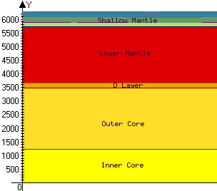
| Modeling: Draw a diagram
TO
SCALE from the center of the earth to the surface (you may even want
to include oceans and atmosphere). It is very important that you research
the appropriate thickness of each of the Earth's subdivisions (crust, mantle,
core, asthenosphere, etc.) and draw them as carefully as you can. The reason
for this is because many of the diagrams you will see on the web and in
textbooks have greatly exaggerated the thickness of various subdivisions
for the sake of a clear diagram.
At right is the picture I made using Advanced Grapher; I plotted the lines y = 1228, y = 3488, y = 3678, y = 5728, y = 5878 and y = 6378. This then depicts how a flat-earth type might view these layers... |
 |
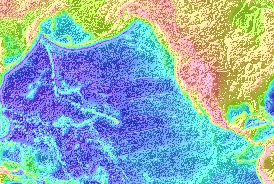
Researching Part 1: Examine the graphic of Sea Floor Topography carefully, pay particular attention to the shapes of trenches and the offset patterns of mid-oceanic ridges. From your reading and examination of this image, describe in your own words the origins of spreading center patterns (i.e., the transform fault offsets)*, and the patterns of subduction zones (i.e., arcuate trenches and arcuate island arcs)*.
Compare the Pacific Ocean floor and surface topographies shown in the two pictures below:
 |
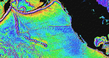 |
It occurs to me that the motion of the ocean due to tides is what causes the surface contour to correspond to the floor contour. Compare a still pond to a stream. The pond water settles to gravitational equilibrium. With a stream, the water is flowing over rocks, etc and the surface tends to follow these contours.