-
Determine the age of the sea floor off the eastern
shore of the US.
The sea floor is relatively old here. 150
million years or more.
-
Determine the age of the sea floor off the coast
of northwestern Africa.
Again, this is old floor: about 150 million years
or more.
-
Acquire the distance between South Carolina coast
and the northwestern African coast.
At http://www.nau.edu/cvm-cgi-bin/latlongdist.pl you can enter 33N,
80W as the latitude, longitude coordinates of South Carolina and 20N, 18W
for the coordinates of northwest Africa. The Perl script there computes
this distance to be roughly 4000 miles. The longitude/latitude coordinates
were obtained by going to the world atlas at http://www.mapquest.com/ .
-
Calculate the rate that the continents are moving
apart. (express your answer in centimeters per year)
Wow. I've been searching for this info
for days. I visited a lot of interesting sites that didn't have the
velocity information I'm after, such as like these two:
http://kids.earth.nasa.gov/archive/pangaea/index.html
http://pubs.usgs.gov/publications/text/historical.html#anchor4833509
but there is what looks like solid data at the Scripps Orbit and Permanent Array
Center (SOPAC)
http://sopac.ucsd.edu/
which you can follow to
http://sopac.ucsd.edu/cgi-bin/ohio?cx=0.0&cy=0.0&scale=136200000&file=all.map&legend=arrays
showing a number of selectable world-wide sites where you can find
measured ground movement velocities.
Pursuing this thread through:
http://sopac.ucsd.edu/cgi-bin/dbShowArraySitesMap.cgi?array=ALL&array_option=siteList
http://lox.ucsd.edu/cgi-bin/dbPermanentGPSSites.cgi
and using the navigation tools on the clickable map there, arrive at
http://lox.ucsd.edu/cgi-bin/ohio?cx=-88.48914855&cy=35.24850798&scale=60093896&file=all.map&legend=networks
where, for instance, the site "cha1" is observed on the SE US coast,
among many others.
Following other links to
http://lox.ucsd.edu/GPSProcessing/showsite/
you can type in "cha1" in the query box. We find this is a site
in Charleston, South Carolina with latitude 32.76N and longitude -79.84
(the negative sign means it's west) at an elevation of -29.03 m .
Other coordinates given for this site are (x,y,z) = (946821.79,-5284901.53,3431363.11)--though
I'm not sure what those mean yet. To find out more about this, try
http://lox.ucsd.edu/GPSProcessing/coordinates/coords_help.html
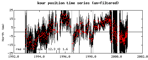
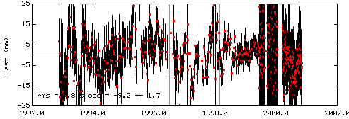
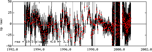
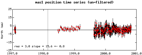
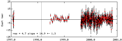
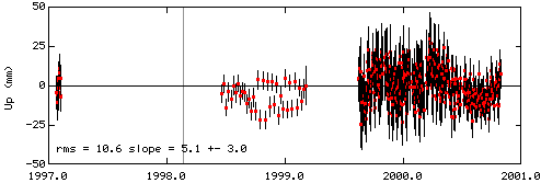
Looking at the site at Kourou, French Guyana, which is on the northeast
coast of South America at lat=5.25, long=-52.81 and elev=-25.57, the site
gives us the following "unfiltered" display of three dimensional velocity:
These graphics seem to indicate that this location is moving at a rate
of about 12 mm/yr north, 9 mm/yr west and 4.8 mm/yr up. Looking at
the GPS in Maspalomas (an island off northeast Africa) we find
Apparently, this location in NE Africa is moving at about 16mm/yr north,
15mm/yr east and and 5mm/yr up.
Together, this tends to support the theory that these two land masses
are moving apart (Africa to the east and South America to the west).
NEXT