Teacher Directed Questions: Portfolio questions-Please
discuss your reasons for your choices. In class discussion--what features
did you find, does something appear NOT to
fit, what are the features that you found?
The NOAA has something they call the National
Environmental Satellite, Data, and information Service, which is located
at http://ibis.grdl.noaa.gov/SAT/SAT.html which is a great source for info
related to these sea topography phenomena. Also the Topex/Poseidon Analyses
from NOAA at http://ibis.grdl.noaa.gov/SAT/hist/index.html, which is described
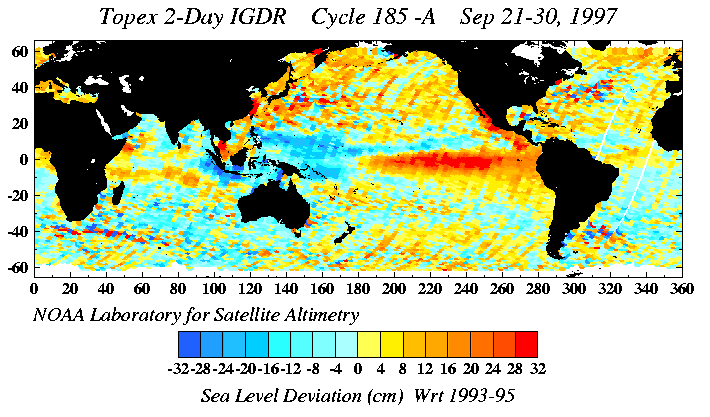
at http://ibis.grdl.noaa.gov/SAT/hist/tp_products/topex.html, has all kinds
of info akin to that shown below:
They have averaged these over the course of many recent years (separately)
to produce graphics such as this:
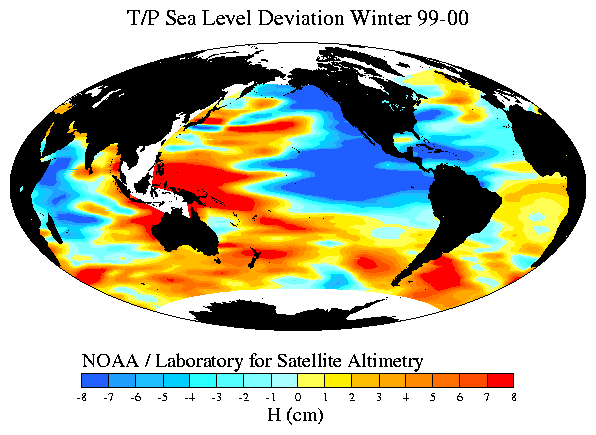
There are some curious features here. To find out more of what
it's about, I went to the site of Robert E. Cheney (http://ibis.grdl.noaa.gov/SAT/pubs/bob.html)
and read the article THE FUTURE OF SEA SURFACE HEIGHT OBSERVATIONS,
by a bunch of researchers including Gary T. Mitchum with Department of
Marine Science at University of South Florida. The abstract of the
paper is below:
ABSTRACT - A brief review of the use of sea surface height (SSH) data
for climate-related research is given that serves to identify key constraints
on a strategy for obtaining SSH observations in the future. The present
status of the SSH observing system is reviewed, and a plan for the future
observing system that builds on the present system is developed. We conclude
that the technology for maintaining an effective SSH observing system is
available now, and given resources, this system can make a significant
contribution to CLIVAR.
Researching Part 3: The newest
oceanic crust is found closest to mid-oceanic ridges*, while ocean
crust that is found farther away from spreading centers* is older and has
accumulated more water-saturated sediment. Examine the ocean floor
map carefully, and write a report on the geological future (very long term!)
of the Pacific and the Atlantic oceans. Include in your report some reasons
why the Pacific Ocean has so many trenches, while the Atlantic has none,
and why the Atlantic ocean is so symmetrical (with respect to age of crust
and the mid-oceanic ridge), while the Pacific is so asymmetrical.
Teacher Directed Questions: Students should include
in their portfolio answers to the essay questions from above. What do you
think caused the trenches, why are the oceans different in shape?
There are some new terms here. Bathymetry, for
instance: ba•thym•e•try (Pronunciation: (bu-thim'i-trE))—n.
1. the measurement
of the depths of oceans, seas, or other large bodies of water.
2. the data
derived from such measurement, esp. as compiled in a topographic map.
It seems that the Atlantic Ocean is caused by
the splitting and pulling apart of Pangaea
This idea is supported by the animations at http://www.ucmp.berkeley.edu/geology/tectonics.html.
In particular, examining the movie at http://www.ucmp.berkeley.edu/geology/tecall1_4.mov
and the Pacific Ocean is where continental masses are being pushed towards
eachother.
Hmm, searching the Elsevier library database
under "bathymetry plate halfspace" produces just one article:
An independent test of thermal subsidence
and asthenosphere flow beneath the Argentine Basin, by Warren L. Hohertz,
Richard L. Carlson of Department of Geology & Geophysics, Texas A&M
University, which includes the following abstract:
Abstract
"We have used primary precision depth recorder
and single channel seismic data from three cruises of the R/V Conrad
to test thermal subsidence and asthenosphere flow models for seafloor depth
versus age in the Argentine Basin in the western South Atlantic. We found
a region in the west central part of the basin where anomalously shallow
depths, that can not be explained by any simple thermal or dynamic model,
are associated with a local free-air gravity anomaly. Elsewhere, over ages
ranging from 1 to 104 Ma, there is no evidence of the “flattening” of the
depth/age trend that is characteristic of the plate cooling model for the
thermal subsidence of the oceanic lithosphere. The halfspace thermal subsidence
model accounts for nearly 98% of the variance of seafloor depth, but the
slope, b = 425 +/- 10 m Ma^(-1/2) implies improbably high mantle temperatures
and/or low mantle densities. Moreover, there is some systematic misfit
between the data and the halfspace model. A thermal subsidence model in
which initial conditions vary with age accounts for the misfit, but also
requires an implausible variation of mantle temperature and/or density.
Alternatively, a model that includes the effect of induced flow in the
asthenosphere eliminates the misfit and yields a reasonable rate of thermal
subsidence b = 330 +/- 20 m That the mantle temperature (Tm ~ 1150
+/- 70) implied by the subsidence rate is slightly lower than normal is
consistent with the hypothesis that this region has not been affected by
hot spots or mantle plumes. The viscosity of the asthenosphere derived
from the model (3-4X10^19 Pa s) is high, but consistent with viscosities
estimated from plate dynamics models when the low mantle temperature is
taken into account. Finally, the PMS flow model is consistent with measured
heat flow in the region. These results lend weight to the hypothesis that
the bathymetry of the Argentine Basin is influenced by induced flow
in the asthenosphere, as well as by halfspace cooling of the upper mantle
(C) 1998 Elsevier Science B.V. All rights reserved."
Did you get all that? This Argentine Basin is off the southeast coast
of South America?
NEXT