ACTUAL TIDES IN THE OCEAN
Progressive Tides in Canals--Let us consider a long narrow canal, open at both ends, along which a tidal wave is progressing. In accordance with the well-known properties of progressive waves, the water particle velocity at the crests of the wave will be in the same direction as that of the propagation of the wave form, while the water particle velocity at the troughs will be in the opposite direction.
Now, the rotation of the earth tends to deflect any particle in motion to the right (in a horizontal plane in the northern hemisphere) relative to the earth with an acceleration proportional to the speed of the particle. This is the so?called Coriolis acceleration that was discussed above. In order to balance this Coriolis uceleration the water surface at the crest must slope upward to the right (in the northern hemisphere), if one is facing in the direction of propagation of the wave. Similarly, the water surface at the trough must slope upward toward the left. Therefore, the crests are higher and the troughs lower along the right coast of the canal, and at any point on the right coast of the canal there will be a higher range of the tide than for a point situated on the left coast.
The above considerations are substantiated by tidal observations in the English channel and Irish sea. The tidal wave progresses eastward through the English channel passing out through the Straits of Dover into the North sea. The tidal range is greater on the French coast (the right side) than on the English coast . In the Irish sea, the tidal wave progresses northward, and the tidal range is greater on the English and Welsh coasts (again the right side) than on the Irish coast.
Tides in Adjacent Seas.--If the region under consideration is small enough the tide within it is influenced predominantly by the tide immediately outside the region and not appreciably by the direct action of the tide-generating forces. It is on the water of the great oceans that the gravitational forces of the moon and sun generate the greater part of the tide, while the tides in the small seas bordering the oceans can be considered as free waves.
A great deal of theoretical work has been done on the tides of adjacent seas, but invariably it is necessary to approximate the sea by some simple geometric shape. Nevertheless, many satisfactory explanations of the actual tide in small bodies of water have been obtained.
The theory of free long waves states that a tidal wave in a narrow canal
of constant depth is propagated with a velocity of ![]() ,
the wave length being given by the expression
,
the wave length being given by the expression ![]() ,
where g is the acceleration of gravity, h is the water depth
and T is the period of the wave (time interval between successive
high waters). In the case of the tide, T will have approximately the value
of 12 hr. for the semidiurnal tide, or 24 hr. for the diurnal tide.
,
where g is the acceleration of gravity, h is the water depth
and T is the period of the wave (time interval between successive
high waters). In the case of the tide, T will have approximately the value
of 12 hr. for the semidiurnal tide, or 24 hr. for the diurnal tide.
| Let us neglect, for the time being, the
effect of the earth's rotation and consider a tidal basin of constant depth
having rectangular shape with one end closed and the other end in communication
with the ocean. Only motions parallel to the length of the basin will be
considered. The tides within the basin are influenced by the boundary conditions
(1) that the elevation at the mouth of the basin is at any instant the
same as that in the ocean immediately exterior to the basin; and (2) that
the horizontal orbital motion at the closed end vanishes. The situation
is analogous to the acoustical problem of stationary oscillations within
an organ pipe open at one end. The spatial distribution of amplitude of
the oscillation is characterized by the positions of nodes, or places where
there is no tidal oscillation of the water surface, or no pressure oscillation
in the case of the organ pipe, and of antinodes or places where the oscillations
attain their maximum amplitude. A standing wave in the pipe has an antinode
at the closed end, while one quarter of a wave length away there is a node,
and so forth, with nodes and antinodes alternating along the length of
the pipe with a quarter of a wave length between them. If the open end
is at or near a node the oscillation within the pipe attains a magnitude
much greater than that outside the mouth of the pipe, and resonance is
said to occur. Thus, in the case of the rectangular tidal basin, resonance
would occur if the length L of the basin had any of the values
|
|
Or, for a given length, resonance would occur if the period of oscillation had any of the values
[Note: Check out the web page of UC Davis' Professor Pasternack in particular: http://lawr.ucdavis.edu/faculty/gpast/tides.html for more info on free modes of oscillation in tidal estuaries.]
If the basin is less than a quarter of a wave length long, the entire basin oscillates with the same phase. If the length of the basin is between a quarter wave length and a half wave length, there is one nodal line and the oscillation at the head of the basin is 180° out of phase with that at the mouth. Every node line represents a phase change of 180°..
The Bay of Fundy on the east coast of North America has the greatest tidal range of any place on earth, and this fact is attributed to a resonance phenomenon based on the foregoing considerations. The shape of the Bay of Fundy is reasonably well approximated by a rectangular basin having a length of 170 mi. and a depth of 240 ft. The above relationships indicate that such a basin would have a resonance period of approximately 11.5 hr-which is very close to that of the sernidiurnal tide. It Should therefore be expected that the semidiurnal tide would be greatly magnified relative to the diurnal, and this is found to be the case. At certain places at the head of the bay the spring tide attains a range of 50 ft.
Elongated seas of variable depth and cross-sectional area can be studied mathematically provided these quantities vary slowly enough along the length of the sea. Good agreement between theory and observation has been obtained for tides in the Gulf of California, the Red sea and other adjacent seas. The Gulf of California is computed to have a resonance period of approximately 25 hr., roughly that of the diurnal tide. The tide at the head of the gulf near the mouth of the Colorado river has been observed to be predominantly diurnal in character with a maximum range of approximately 20 ft. The computed variation of amplitude and phase of the M2 constituent in the Red sea is in good agreement with the observed variation, and both theory and observations indicate the presence of a nodal line close to Port Sudan, near the mid-point of the sea's length.
To consider geostrophic effects (i.e., those resulting from the earth's
rotation) it is necessary to take into account the Coriolis acceleration.
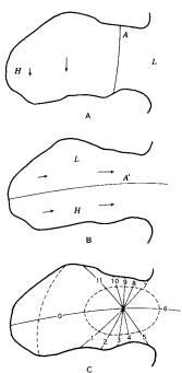
Consider a standing oscillation in a gulf as shown in fig. 2A at the instant
of high water at the head of the gulf. The
curve A has been drawn through all points where the deviation the water
level from its mean is zero at this instant. One quarter
period later the water is flowing out of the gulf. At this instance
in the absence of the Coriolis force, the elevation everywhere
within the gulf would have its mean value (except for a small frictional
effect), and the curve A would represent a nodal
Actually, the elevation will be higher to the right of the outward
flowing current, as is shown in fig. 2B, with the curve A' lying along
points whose elevation is at the mean level. Continuity considerations
show that there must have been currents flowing at the instant of high
water within the gulf in order to produce the distribution of water level
shown in fig. 2B. Possible directions these currents are shown in fig.
2A.
At the intersection of the curves A and A' there will be no rise and fall of sea level, and such a point is known as an amphidromic point.[animation] [Patagonian Shelf Model Results] [North Indian Ocean] Let it be assumed that the constituent under consideration is a semidiurnal one, and divide its period into 12 equal time-intervals called constituent hours, and let the zero constituent hour correspond to the instant of high water within the gulf as depicted by fig. 2A. Fig. 2C then gives the curves along which high water occurs for each of the 12 constituent hours. Such curves are called cotidal lines. The hypothetical distribution of range of tide is indicated by the dashed curves, called corange lines, each of which connects points having equal range of tide. The amphidromic point, at which the tidal range is zero, lies in the centre of the concentric family of corange lines. The cotidal lines indicate the position of the crest of the tidal wave at any instant, and it is seen that this crest rotates in counterclockwise fashion (in the northern hemisphere) about the amphidromic point. Such amphidromic systems with counterclockwise movement of the tidal crest are characteristic also of the oceans and adjacent (large) bodies of water.
Geographical Distribution
of the Ocean Tide.--Cotidal maps, such as the one described above,
are useful in illustrating the distribution of tidal elevation in a body
of water, but it should be kept in mind that such charts are, strictly
speaking, useful only in describing a single harmonic constituent. In theory
it would be necessary to have one complete cotidal map of the world's oceans
for each and every tidal constituent in order to characterize completely
the form of the tidal wave, or the rise and fall of water at every point
in the ocean. The only constituent for which such charts have been prepared,
to any extent, has been the M2constituent, which is somewhat
representative of the other semidiumal constituents.
|
Except along the boundaries
of the oceans the tidal elevations are extremely difficult to measure,
and what meagre knowledge we have of the geographic distribution of the
tide in the whole ocean has been deduced principally by extrapolating from
coastal tide stations and, where possible, making use of tidal current
measurements. The equations of motion connect the tidal currents with the
elevation gradients and external forces, including those of friction, and
so from a knowledge of the currents and a law for the frictional forces
the elevation gradients can be calculated. When the elevation is also known
at a particular point, the directions of the cotidal and corange lines
and also the distance apart of neighbouring members of these families of
lines can be calculated. Such conditions are fulfilled for many coasts.
If the elevation gradients can be calculated along a line which passes
through one or more points at which the elevation is known, it is clear
that the elevation can be calculated all along the line. In this
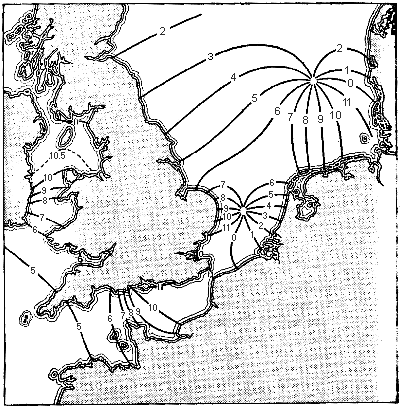
way the semidiurnal (M2) tide over the North and
Irish seas was determined by Proudman and Doodson in 1923
(see
fig.
3).
|
|
|
Cotidal charts for the
M2constituent
have been prepared for the oceans but they are uncertain, however, especially
at large distances from the coasts and islands where tide gauge observations
have been made. Tidal current determinations are rarely made in the open
ocean. Another difficulty is that tide gauges are frequently located in
sheltered bays or atoll lagoons where the time of high water may be delayed
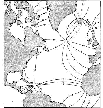
by as much as several hours. The cotidal chart of the Atlantic ocean shown
in fig. 4 was prepared by Stemeck in 1920.
|
FIG. 4.--COTIDAL CHART OF THE ATLANTIC OCEAN
|
Mathematical solutions for the tide in ocean basins of simplified shapes have been obtained. Laplace in 1776 studied the dynamical problem of the semidiurnal tide in an ocean covering the entire earth and having constant depth. His solution takes into account the inertia of the water and the rotation of the earth. Some interesting aspects of this solution are summarized in Table III.
|
|
|
|
|
|
|
|
|
|
|
|
|
|
|
|
Positive values in the
second column indicate that the tide at the equator is direct--that is,
that high water occurs simultaneously with high water of the equilibrium
tide. Negative values indicate that the tide is inverted, or 180° out
of phase with the equilibrium tide. For the diurnal tide Laplace obtained
the curious result that there is no tidal oscillation of elevation on this
worldwide ocean of constant depth, although there are tidal currents.
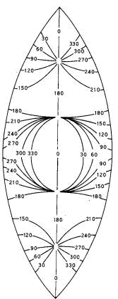
Several solutions have
been obtained for the special case of an ocean of constant depth bounded
by two meridians. The result of one of the solutions obtained by Proudman
and Doodson is shown in fig. 5, which represents a cotidal chart of the
K2tide
in an ocean of depth 14,520 ft. bounded by meridians
70°
apart.
The K2 tide was selected because of mathematical
simplifications, but the M2 tide should be quite
similar. Comparison of fig. 5 representing a mathematical solution
with fig. 4 derived from observations discloses no striking similarities
except for the general occurrence of arnphidromic systems.
|
|
Tides in Lakes.-If
all natural periods of oscillation of a completely enclosed basin are short
as compared to those of the tidal constituents, the tide should be approximately
at equilibrium with the tide-generating forces at all times. According
to the theory of long-standing waves in a rectangular basin of constant
depth, the length of the basin is equal to one-half wave length of its
gravest free mode. The period of the gravest mode is given by the expression ![]() where
L
is the length of the basin. For example, the gravest mode of a lake
20 km. long having constant depth of 40 m. willhave a period
of approximately 0.5 hr. accordifig to the above formula, and the tide
in such a lake would therefore be determined with quite sufficient accuracy
by static principles.
where
L
is the length of the basin. For example, the gravest mode of a lake
20 km. long having constant depth of 40 m. willhave a period
of approximately 0.5 hr. accordifig to the above formula, and the tide
in such a lake would therefore be determined with quite sufficient accuracy
by static principles.
If the above condition is fulfilled the slope of the lake's surface is equal, at any instant, to the slope of the equilibrium tide at that location, and the actual tidal elevation at any point within the lake is determined by the condition that the total volume of water remain constant. The tide will usually differ considerably from the equilibrium tide according to these conditions, generally being considerably smaller in amplitude. For example, the maximum slope of the equilibrium tide is of the order of a metre in one-fourth the earth's circumference, 10,000 km., giving a value of 10-7. For a lake whose length is 10 km. the maximum difference of elevation between its extremes will be of the order of 10x10-7 km. or 1 mm. The tide in small lakes is thus seen to be extremely small, and is usually overshadowed by other effects such as a variable amount of water volume related to variable runoff and evaporation, wind effects, seiches, etc.
There is no variation of tidal elevation at the centroid of the lake's surface area. If the gravest free oscillation of the lake approaches that of the semidiurnal tide, then of course the above concepts no longer are true, and a dynamical treatment of the problem is necessary. This elementary discussion has also omitted two other important effects: the yielding of the lake's bottom with the tidal deformation of the earth's body, and the potential of the tidally displaced matter of the earth (see section X).
The 1969 Encyclopedia Britannica entry under "tide:"
[Page1] [Page2]
[Page3] [Page4]
[Page5] [Page6]
[Page7] [Page8]